The tsunami of 17 July 2006
The tsunami which hit the island of Java (Indonesia) on 17 July 2006 was caused by an earthquake of a magnitude of Mw=7.7. It occurred at 8:19:25 (UTC, Coordinated Universal Time). The coordinates of the epicentre are 9.311° S, 107.284° E (USGS), located to the south of Java. The calculated depth of the hypocenter is 48.6 km.
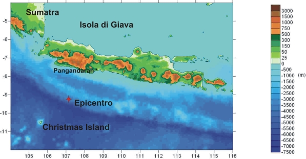
Fig. 1: Map of the
island of Java showing the epicentre of the tsunami and Pangandaran, the most affected
province. |
Just like the Sumatra earthquake of 26 December 2004, this earthquake occurred in a sector of the subduction zone along which the Australian plate is sliding under the Sunda plate at a rate of 59 mm/year. The first reasonable estimates of the size of the fault could be: length=100 km, width=50 km, slip along fault =2.5 m.
The tsunami affected an area of approximately 150 km along the south coast of Java, around and to the east of the town of Pangandaran. The first observed movement of the sea was a withdrawal, followed after about half an hour by a flood. Unfortunately, there are no instrumental data regarding the arrival time of the tsunami on the Java coasts. The first estimates of the impact show that, locally, the waves reached a height of 5 metres and penetrated a few hundred metres into some villages east of Pangandaran. Estimated figures are 525 dead and 383 injured
(http://earthquake.usgs.gov).
The tsunami also affected Christmas Island, 230 km south-west of Java, and was recorded by various tide-gauges located in different states on the Indian Ocean. To get a general idea of the propagation time, the tsunami reached Christmas Island in approximately 18 minutes, while it was recorded in Rodriguez in Mauritius approximately 6 hours 45 minutes after the earthquake.
Tsunami alarm bulletins were issued by both the Pacific Tsunami Warning Center (PTWC) and the Japanese Meteorological Agency (JMA). The first PTWC bulletin was issued 17 minutes after the earthquake, i.e. before the tsunami waves arrived on the coasts of Java. The second bulletin came just less than two hours after the earthquake, when the tsunami had already hit Java. In the first bulletin, the risk of a possible tsunami was in fact underestimated, since it said that a local tsunami could hit coastlines not more than a hundred kilometres from the epicentre.
Tsunami simulations carried out by the Tsunami Research Team of the Physics Department, Bologna University are available on the website http://labtinti4.df.unibo.it